Hiking

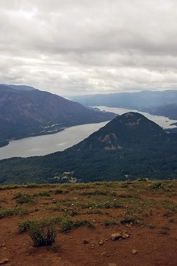
Angel's Rest
Angel's Rest is a popular 4.5 to 4.8-mile, moderately difficult out-and-back hiking trail in the Columbia River Gorge, Oregon, renowned for its 270-degree panoramic views. Located near Bridal Veil, the hike gains 1,500 feet in elevation, featuring rocky terrain, waterfalls, and stunning views of Beacon Rock and the Columbia River.


Broken Top
Broken Top is a glacially eroded complex stratovolcano. It lies in the Cascade Volcanic Arc, part of the extensive Cascade Range in the U.S. state of Oregon. Located southeast of the Three Sisters peaks, the volcano, residing within the Three Sisters Wilderness, is 20 miles (32 km) west of Bend, Oregon, in Deschutes County. Eruptive activity stopped roughly 100,000 years ago, and erosion by glaciers has since reduced the volcano's cone to where its contents are exposed. There are two named glaciers on the peak, Bend and Crook Glacier.


Cooper Creek Reservoir
Cooper Creek Reservoir is a body of water behind an earthen dam across Cooper Creek in the Umpqua River basin of the U.S. state of Oregon. The reservoir is in Douglas County, about 2 miles (3 km) east of Sutherlin and about 11 miles (18 km) north of Roseburg. The impoundment provides part of Sutherlin's drinking water.

Detroit Lake
Detroit Lake is a reservoir impounded by the Detroit Dam on the North Santiam River 46 miles (74 km) southeast of Salem, Oregon, United States. The lake is adjacent to Oregon Route 22 near the city of Detroit. This mesotrophic lake stores water for use by the city of Salem and other nearby communities.
Diamond Lake
Diamond Lake is a natural body of water in the southern part of the U.S. state of Oregon. It lies near the junction of Oregon Route 138 and Oregon Route 230 in the Umpqua National Forest in Douglas County. It is located between Mount Bailey to the west and Mount Thielsen to the east; it is just north of Crater Lake National Park.
Dog Mountain
Dog Mountain rises above the north side of the Columbia River Gorge in the U.S. state of Washington. The base of the mountain is in Skamania County along Washington State Route 14, about 9 miles (14 km) east of Stevenson and 53 miles (85 km) east of Vancouver. From its base at 150 feet (46 m), it climbs steeply to an elevation of 2,948 feet (899 m).


Larch Mountain
Larch Mountain is an extinct volcano near Portland, Oregon. The name is misleading, as no western larch (a large coniferous tree) can be found there. It received that name when early lumbermen sold the noble fir wood as larch. The peak can be reached between May and November on paved Larch Mountain Road, 16 mi (26 km) east of Corbett, Oregon, although the road is closed during the winter and spring months. The road leading to Larch Mountain from the Historic Columbia River Highway is 14 miles long, which closed at milepost 10 from Nov. through late May or early June due to snow.
Maiden Peak
Maiden Peak is a steep-sided shield volcano in the Cascade Range of central Oregon. It is the highest point in the 43-mile (69 km) distance between Mount Bachelor and Diamond Peak. Ice Age glaciers carved a large cirque into the northeast flank of the mountain, exposing magma which hardened in the volcano's conduits to form the numerous rock pinnacles now found in the upper part of the cirque.

Mount Bailey
Mount Bailey is a relatively young tephra cone and shield volcano in the Cascade Range, located on the opposite side of Diamond Lake from Mount Thielsen in southern Oregon, United States. Bailey consists of a 2,000-foot (610 m)-high main cone on top of an old basaltic andesite shield volcano. With a volume of 8 to 9 km3 (1.9 to 2.2 cu mi), Mount Bailey is slightly smaller than neighboring Diamond Peak. Mount Bailey is a popular destination for recreational activities. Well known in the Pacific Northwest region as a haven for skiing in the winter months, the mountain's transportation, instead of a conventional chairlift, is provided by snowcats—treaded, tractor-like vehicles that can ascend Bailey's steep, snow-covered slopes and carry skiers to the higher reaches of the mountain. In the summer months, a 5-mile (8 km) hiking trail gives foot access to Bailey's summit.
Mount Scott
Mount Scott is a small stratovolcano and a so-called parasitic cone on the southeast flank of Crater Lake in southern Oregon. It is approximately 420,000 years old. Its summit is the highest point within Crater Lake National Park, and the tenth highest peak in the Oregon Cascades. A small fire lookout tower stands on the summit, at the end of a trail that zigzags approximately 1,500 feet (460 m) up the mountain. The mountain is named for Oregon pioneer Levi Scott, founder of Scottsburg, Oregon.

Mount Washington
Mount Washington is a deeply eroded volcano in the Cascade Range of Oregon. It lies within Deschutes and Linn counties and is surrounded by the Mount Washington Wilderness area.
Like the rest of the Oregon Cascades, Mount Washington was produced by the subduction of the oceanic Juan de Fuca tectonic plate under the continental North American tectonic plate, forming during the late Pleistocene. Made mostly of mafic (rich in magnesium and iron) volcanic rock like subalkaline basalt and basaltic andesite, it has a volcanic plug occupying its summit cone and numerous dikes. It is surrounded by other volcanic features such as cinder cones and spatter cones. The volcano's last eruptions took place from spatter cones about 1,350 years ago, generating basaltic andesite lava deposits.


Three Fingered Jack
Three Fingered Jack is a summit of a shield volcano of the Cascade Range in the U.S. state of Oregon. Formed during the Pleistocene epoch, the mountain consists mainly of basaltic andesite lava and was heavily glaciated in the past. While other Oregon volcanoes that were heavily glaciated—such as Mount Washington and Mount Thielsen—display eroded volcanic necks, Three Fingered Jack's present summit is a comparatively narrow ridge of loose tephra supported by a dike only 10 feet (3.0 m) thick on a generally north–south axis. Glaciation exposed radiating dikes and plugs that support this summit. The volcano has long been inactive and is highly eroded.
Tipsoo Peak
The trail is a series of wide switchbacks traversing through a widely spaced mountain hemlock-true fir forest with little ground vegetation. After about a mile the trail enters Mount Thielsen Wilderness. The last mile has open dry meadows. The final 500 feet to the top is a scramble along a narrow rocky ridge. Views from the top are spectacular and include Diamond, Miller and Maidu Lakes, Mt. Bailey, Mt. Thielsen and other Cascade peaks to the north and south.
At the top, expect gusty winds. The Pacific Crest National Scenic Trail is a 0.3-mile scramble down the southeast side of the peak. This route is not marked or managed as a trail.


